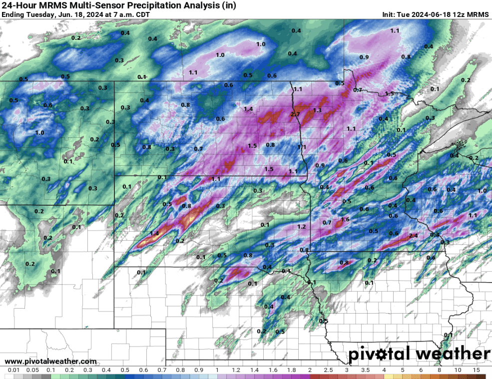
As a slow moving cold front ‘stalled’ across Eastern North Dakota and Minnesota overnight Monday (6/17/18) into the morning hours of Tuesday (6/18/24). Strong and severe storms developed and trained along this front with strong winds and heavy downpours. A few wind gusts topped 75 mph with likely some unobserved gusts near 80 mph. General reported wind gusts as of Tuesday morning were in the 50-70 mph range.
| 01:07 am CDT – 6/18/2024 | Dazey, ND | Tstm Wnd Gst | 72 MPH |
| 03:01 am CDT – 6/18/2024 | Ada, MN | Tstm Wnd Gst | 67 MPH |
| 01:57 am CDT – 6/18/2024 | 7 N Verona, ND | Tstm Wnd Gst | 67 MPH |
| 09:50 pm CDT – 6/17/2024 | 1 N Stanton, ND | Tstm Wnd Gst | 67 MPH |
| 09:30 pm CDT – 6/17/2024 | 1 SSW Coleharbor, ND | Tstm Wnd Gst | 67 MPH |
| 02:05 am CDT – 6/18/2024 | Englevale, ND | Tstm Wnd Gst | 67 MPH |
| 09:30 pm CDT – 6/17/2024 | 2 NW Fort Clark, ND | Tstm Wnd Gst | 65 MPH |
| 01:10 am CDT – 6/18/2024 | Logan Center, ND | Tstm Wnd Gst | 61 MPH |
| 03:20 am CDT – 6/18/2024 | Moorhead, MN | Tstm Wnd Gst | 60 MPH |
| 01:15 am CDT – 6/18/2024 | 5 WSW Kulm, ND | Tstm Wnd Gst | 60 MPH |
| 01:09 am CDT – 6/18/2024 | 3 NE Jamestown, ND | Tstm Wnd Gst | 60 MPH |
| 12:16 am CDT – 6/18/2024 | 1 N Pollock, SD | Tstm Wnd Gst | 60 MPH |
| 04:26 am CDT – 6/18/2024 | Park Rapids, MN | Tstm Wnd Gst | 59 MPH |
| 09:04 pm CDT – 6/17/2024 | 1 W Garrison, ND | Tstm Wnd Gst | 59 MPH |
| 01:50 am CDT – 6/18/2024 | 3 S Marion, ND | Tstm Wnd Gst | 58 MPH |
| 02:05 am CDT – 6/18/2024 | 1 SE Mallory, MN | Tstm Wnd Gst | 57 MPH |
| 01:30 am CDT – 6/18/2024 | 3 WNW Emerado, ND | Tstm Wnd Gst | 56 MPH |
| 02:15 am CDT – 6/18/2024 | Crookston, MN | Tstm Wnd Gst | 55 MPH |
| 02:00 am CDT – 6/18/2024 | 5 N Grand Forks, ND | Tstm Wnd Gst | 55 MPH |
Rainfall in some areas was on the higher end, especially with how saturated the soils are. Amounts generally fell into a one to three inch range with localized areas over four inches of measured rainfall as of 7:00 am Tuesday.

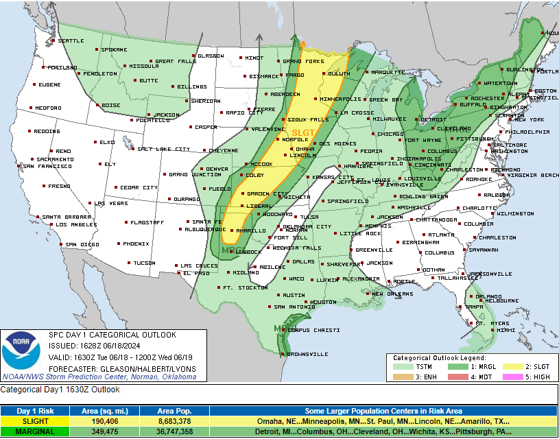
Rain and storms Continue in the far Southern Valley of the Red River Tuesday Morning, and will continue as the slow moving cold front pushes further east into Minnesota where there is still a slight right for severe storms this afternoon and evening.

Storm Prediction Center Day 1 Severe Weather Outlook Via Storm Prediction Center
Meteorologist,
Justin Storm


