HERE’S WHAT IS HAPPENING IN SO. CAL CURRENTLY:
Major storm hitting Southern California:
NWS Los Angeles (@NWSLosAngeles) on X
As of 1120 PM, DT Los Angeles was at 3.89″ of rain today which far surpasses the daily rainfall record for Feb 4th of 2.55 inches set in 1927. Is also the 3rd wettest Feb day and 12th wettest day for any time of year since records began in 1877. #LARain
EXTREMELY DANGEROUS SITUATION UNFOLDING IN THE HOLLYWOOD HILLS AREA AND AROUND THE SANTA MONICA MOUNTAINS Life threatening landslides and additional flash flooding expected overnight tonight. Avoid travel if at all possible. #LArain #CAwx #Socal #Californiastorm
LOOK AT WHAT HAPPENED 45 DAYS AGO…. (LA TIMES ARTICLE)
During that same time, we were getting ready for a MAJOR Christmas Ice storm. We knew at that time, according to the LRC, that this storm would be back in early February (45 day cycle)
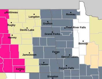
We have had a mild winter with 23 records being set so far (quite a few of those are record WARM morning lows) and it looks like we will be on the WARM side of this storm too….at least at the beginning. Look for RAIN to overspread the F/M area Wednesday night into Thursday with 1/2″ to 1″ possible across the area. As colder air moves into the area the rain will change to snow Thursday night and into Friday. Currently, it looks like minor accumulations across the area (see snow map) I’m not totally sold on how the models are handling this storm in our area so if you have any travel plans over the N. Plains toward the latter part of the week, keep up to date on the forecast.
The LRC is a POWERFUL forecasting tool which only 10 meteorologists across the country know how to use. With this storm rolling through, we know it will cycle back toward the end of March….let’s hope it’s all rain then!!
Chief Meteorologist,
Dean Wysocki


